Lately in school my daughter and her class are learning all about and communities making maps. They started by designing and constructing buildings from recycled materials. Then they learned about maps and locations. After all the student buildings were turned in (a photo of them because of distance learning) the teacher made a big map of all the student’s buildings. They finished up the lesson by making their own maps of their homes and picturing where this map would be in regards to the world, country, state and city.
Map reading is a great skill that can be taught to kids and adults. Start small and simple with locations and areas you are familiar with. Draw your own map with labels and explain the directions North, South, East and West. Do a few activities and look at a few real maps to get a good map reading foundation.
Map reading isn’t a skill everyone is comfortable with. In a day where smart phones can direct us anywhere some are loosing the ability to tell where they are or read a map on their own. I have been involved with real estate since I was a teenager and learned to read the Thomas Guide, a large book of city maps, for work. Now when we travel I love to get out a map and get a good picture of where we are, where our destinations are and what is around. Our oldest child, 20, relies on her phone for directions and to get to most locations. She isn’t very sure where North, South East and West are relative to her location at home or when at a destination. Teaching basic location is something we are aiming to teach all of our children.
Introducing a Map
When introducing maps, locations and directions start small. Your little one may already be familiar with common locations you drive to. Draw them out on a very simple map.
If I take a new route to my parents house my kids will ask where we are going, they may also tell me we are not going the right way. I remember my nephew almost loosing it in the back seat because I took a new route and he thought I was changing the afternoon plan. He repeated over and over “this is not the way, I want to go to Uma’s”. Eventually he saw we ended up at grandmas and he relaxed. My point is kids pay attention in the car, and you can use that time for teaching directions.
A good way to introduce a map to your kids is to draw out locations they are familiar with, draw places they visit often. Try to keep the area small so they can imagine it and keep it all on one paper. Label streets, houses and landmarks and explain them to your child. Talk about the directions North, East, South and West and draw a compass on the map accordingly.
Talk about how to use directions and how they can be explained to help someone find their way. Some people give directions based on landmarks and others use streets and numbers. I would start by explaining the method you prefer because it will be most familiar. I also encourage you to try explain the opposite way, some prefer to look for landmarks and some don’t. My husband is a landmark driver but I prefer streets so we need to adapt when navigating for the other. It is beneficial to know how to five directions both ways.
Map Activities
- After you have drawn a rough or detailed map of your street or neighborhood talk about how to get from one place to the other using directions. How many streets North or East should you take to get to the park? Do you turn passed the blue house or yellow to get to the corner?
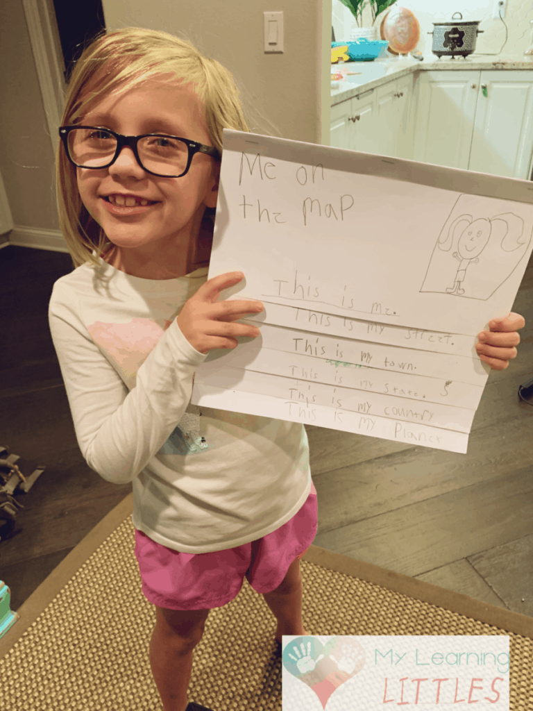
- My daughters first grade class learned about communities, buildings and maps this year. The class worked on an “All About Me” project they titled “Me On A Map” where each child had a few sheets of paper stapled together to make a book. On the fist page they drew a self portrait. Page two was a drawing of their house on their street using a label. Page three was a rough map of the town where they drew their house, school, parks and other locations in town they could think of. They labeled the town, their street and made a small map compass. Next they drew thier state, colored in mountains, rivers, lakes and out a star where their town would be. The fifth page was a drawing of the country and a little notation where their state would be. The last page is a drawing of the planet, labeled Earth and colored in land and sea. It was a cute little project that gave the students a good sense of location and concept of size.
- Take a piece of paper on a walk with you and your child. Start at your house and walk to a park or a neighbors house, draw what you experience as you go. How many street changes do you make? Are there any landmarks? How many houses are on your block? What color are they? Make your map as detailed or simple as you like or think is age appropriate.
Have fun with maps and directions and try to incorporate them in your life as much as possible. If your car has navigation talk about directions and streets as you drive around.
Common Questions
What are the basic skills of map reading?
Basic map reading skills can be simple or complicated depending on the type of map you are reading. If you are reading an atlas you will have less things to know than if you are reading a topographical map or a forestry map. For general knowledge you will be fine with an atlas or street map. If you need something more technical you probably will encounter some on the job training or need to do some studying. So here are some basic map reading skills.
- Picking the right map. The map needs to be of the area you are navigating, in a language you can understand and a map you can understand.
- Understanding of map symbols. Most maps come with a key that can be used to identify different symbols and details featured on the map.
- Understanding of a compass its directions. A map will have a compass printed on it giving an idea to where North is in respect to the map. Have a compass available and be able to line your self up with the map so you can orient yourself in the right position. Most smart phones and cars have compass features.
- Check the map scale. A map scale will help you determine distances from the map to distances in real life.
How do you know which direction is north?
When at home and in surrounding areas I can typically tell where North is. It is in the direction of the Foothills, which I have lived South of my whole life. This summer we took a trip to Colorado and I was really thrown off. The mountains in Colorado were all around and the biggest to the West. I struggled to get my bearings without checking the car compass. I kept thinking West was North.
An easy way to get a basic understanding of North, South, East and West is to look to the sun. The sun rises in the east and sets in the west, at noon it is overhead. To find your directions take your left arm and point it in the direction of the sunrise, then take your right arm and point it to where the sun will set. You now will be facing the South and your back will be to the North. Use this trick to help you find your way and repeat when needed throughout the day.